Learn More About National Get Outdoors Day:
A Celebration of Get Outdoors Colorado!


Getting There
City Park, Denver´s largest park, is easily accessible via bus, bike, or car. Parking is limited, so we highly encourage you to use public transportation, bike, walk, run, or carpool to the event.
Public Transportation: Ride the RTD bus.
RTD bus routes to City Park:
- #20 - east/west along 17th Ave.
- #40 - north/south along Colorado Blvd.
- #32 - east/west along 23rd Ave.
- #24 - north/south along York St.
To plan your trip, http://www.rtd-denver.com. Use the Trip Planner box on top right.
- Type your origin location in the first box.
- Find "City Park" in the second box as a "Points of Interest."
- Click "Plan Your Trip."
For access-a-Ride, call (303) 299-6560.
For additional information, call RTD at (303) 299-6000.
Bike: Ride a bike.
Bike trails, paths, maps, rentals:
- Bicycle Colorado: http://www.bicyclecolorado.org
- BCycle: http://www.bcycle.com/
- Denver bike map: bicycle program maps
- Please note: Google maps offering safe biking directions
Bike lanes near City Park:
16th Ave. to City Park Esplanade21st Ave.
23rd Ave.
Bike-n-Ride on RTD Bus or Light Rail
All buses except the 16th Street FREE Mall Ride are equipped with bike racks on the front. These easy-to-use bike racks can hold two bikes per bus and are available on a first-come, first-serve basis.
Bikes are allowed on Light Rail any time, on a space-available basis, at designated doors only. The closest Light Rail station is 30th & Downing Station. http://www3.rtd-denver.com/LightRail_Map.shtml
Parking: Carpool.
Car Parking
City Park, the largest public park in Denver, is easily accessible by bus or bike. However, if you need to drive, please note that parking is very limited, so we encourage you to carpool, if possible. If you do have to drive, the following are parking lots information.
Handicap Parking
Messiah Community Church
1750 Colorado Blvd 80220
Please note: a shuttle bus will be transporting individuals morning and afternoon during the event.
Exibitors and Volunteer Parking
Please park at the East High School lot or the parking lot on 23rd and Colorado Blvd (by baseball fields). There will be a van running from the school only to event both in the morning and afternoon.
An area art map is available at http://www.denvergov.org/portals/626/documents/parkart/ParkArt_City%20Park.pdf.
Directions:
From the North
Take I-25 south to I-70 east (Exit 214-A), then take I-70 east to York Street (Exit 275-C). Take the York Street south ramp. Turn slight left onto York Street. City Park is on the left.
From the South
Take I-25 north to Colorado Blvd (Exit 204). Take Colorado Blvd north. Turn left onto E 17th Ave. City Park is on the right.
From the East
Take I-70 west to Colorado Blvd (Exit 276-B). Take Colorado Blvd south. Turn right onto Martin Luther King Blvd. Turn left onto York Street. CityPark is on the left.
From the West
Take I-70 east to York Street (Exit 275-C). Take the York Street south ramp. Turn slight left onto York Street. City Park is on the left.
Information Center
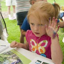
Stop by one of our Information Centers to plan your action-packed day in the park! Here you'll get a complete overview and information on event details. Be sure to pick up your prize entry forms as well as a map, schedule of stage events, and learn how to become a Junior Ranger.
Get into the Outdoors
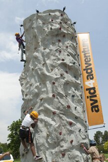
Outdoor recreation adventures! Find what the outdoors have to offer: rock climb, mountain bike, canoe, kayak, and even ski in City Park! Challenge yourself, friends, and family with team building games, and learn to continue your outdoor adventures year-round. Fifth and sixth graders can sign up for free ski passes.
Outdoor Adventure Stage
Ready to (ad)venture outside and learn something new? Challenge yourself and your family. Take advantage of exciting and interactive demonstrations! Discover how rewarding it can be to play as a team, to go on camping trips, to do yoga in bare feet on the grass, to be a contestant on a game show, and much more!
Cultural Connections
Our community is enriched and influenced by the many indigenous, European, and non-European cultures. All cultures make significant and valuable contributions to the place we call home, the State of Colorado. Together we enjoy and draw support from our varied cultures. Come and experience nature and the outdoors through the eyes of different cultures.
Junior Ranger Camp (Ages 2-12)
Experience the wonders of nature and learn basic backcountry skills in the Junior Ranger Camp. Follow the trail and learn how to pack a backpack, set up a campsite, filter water, build and extinguish a campfire, hang your food, and more. You'll also learn how to navigate trail obstacles and find your way in the outdoors using a map and compass or GPS. Discover the types of plants and animals that are living in nature as well as those that lived long ago. Learn how to care for nature and express yourself with an art project. Scouts who complete the camp will get a special event patch, and all kids who participate will get a badge and be sworn in as official National Get Outdoors Day Junior Rangers!
Health Zone
Come get fit and have fun with us! Put on some sunscreen, take the President's Physical Fitness Challenge and participate in a 5k or 10k volksmarch. Receive a prescription for good health. Learn about bicycle safety. Enjoy healthy foods. Value getting off the couch and being more active - outside!
Farmers Market
Summertime is all about FOOD and FUN. To make summertime eating even more delicious, stop by the Farmers Marketplace. Learn what goes into the food you eat and where to find yummy local food in your neighborhood! And when all this food talk starts making you hungry, head over to our local food vendors and grab a healthy, delicious and local snack for you and your family. You can also buy food for later, including fruit, veggies and canned produce, as well as seedlings that will grow into delicious treats right in your yard! The National Get Outdoors Day Farmers Marketplace is sponsored by JeffGROW, the Jefferson Conservation District's urban agriculture program. Booths by May Farms, Colorado Proud, Mountain Valley Canning will be featured.
Take a Family Fishing
Feel the tug on your line as you experience America's favorite pastime: FISHING!!! Experience one of the best and most inexpensive family oriented outdoor activities. Learn how to cast and then try your luck at catching rainbow trout. All equipment and bait is provided. For those 16 years or older, a current Colorado fishing license is required. You can purchase ahead of time online at http://wildlife.state.co.us/ShopDOW/AppsAndLicenses/ or at any sporting goods store. "Take a Family Fishing" sponsors include: Wright and McGill (Eagle Claw), U.S. Bureau of Land Management, U.S. Fish and Wildlife Service, U.S. Forest Service, Denver Water, and Colorado Division of Wildlife.
No Barrier Event
This event is an inclusive event for everyone!
No Barriers USA, Adaptive Adventures, Sportainability, Performance Mobility and the National Sports Center for the Disabled will be in the Get Outdoors Zone sharing their vision of accessibility to the outdoors and active lifestyle opportunities. Stop by to see an accessible motorcycle. Learn to paddle in an adaptive kayak or adaptive canoe. Volunteers will be on-site to assist kids and adults of all backgrounds and abilities in connecting to nature.
Handicap parking will be available in the Messiah Community Church parking lot located at 1750 Colorado Blvd 80220. A shuttle bus, equipped with a wheelchair lift, will be transporting individuals to and from the park during the event.